Montreal topographic map
You can find on this page the Montreal topographic map to print and to download in PDF. The Montreal elevation map present the topography, river and relief of Montreal in Quebec - Canada.
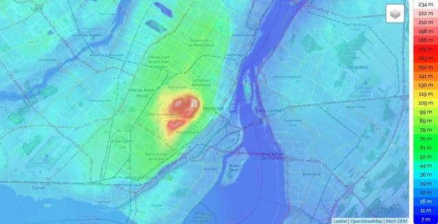
Montreal elevation map
The Montreal topographic map shows elevation, hills and landforms in Montreal. This elevation map of Montreal will allow you to know topography, river and relief of Montreal in Quebec - Canada. The Montreal topographic map is downloadable in PDF, printable and free.
Montreal is located in the southwest of the province of Quebec. The city proper covers most of the Island of Montreal at the confluence of the Saint Lawrence and Ottawa Rivers. The port of Montreal lies at one end of the Saint Lawrence Seaway, which is the river gateway that stretches from the Great Lakes into the Atlantic Ocean. Montreal is defined by its location in between the Saint Lawrence river on its south, and by the Rivière des Prairies on its north as you can see in Montreal elevation map. The city is named after the most prominent geographical feature on the island, a three-head hill called Mount Royal, topped at 232 m elevation above sea level.